

Walking Tours: Recoleta District
Buenos Aires has countless places waiting to be discovered. But if a traveler is visiting the city for the first time and asks me where to start, I would definitely recommend starting with a walk in the Recoleta neighborhood.
Recoleta is mainly residential, and it is one of the most expensive neighborhoods in the city to live. The parks, wide boulevards, art galleries, stylish design stores, museums and its famous cemetery make it one of the most important tourist and cultural neighborhoods. It is, by far, one of the best places to visit in Buenos Aires.
An introduction to Recoleta
The name Recoleta originates from the Monastery of the Recollect Fathers (Convento de Recoletos Descalzos), a faction of the Franciscan Order. The monastery was built on land owned by the barrio’s first mayor, Rodrigo Ortiz de Zarate, after Juan de Garay presented it to him as far back as 1583. At the time, Recoleta was a solitary and desolate area unaware of the changes that were to come.
Recoleta is the neighborhood situated directly northeast of Buenos Aires City Center and shares a border with Almagro, Palermo and Retiro. The barrios popularity began towards the latter part of the 18th century when an outbreak of yellow fever (1871) in the southern suburbs forced the city’s residents to seek refuge elsewhere. Whilst the poorer headed south, the wealthier families chose Recoleta due to its higher terrain thus a lack of disease infecting insects.
With the migration to Recoleta came inevitable development and the new residents were quick to capitalize on the large estates present in the area by dividing them into smaller plots and building upon them. The transformation into a residential barrio was a quick process and the estates were soon replaced with the luxurious stately homes for which it is famed today.
What to do and see in Recoleta
- AVENIDA ALVEAR
The name Recoleta originates from the Monastery of the Recollect Fathers (Convento de Recoletos Descalzos), a faction of the Franciscan Order. The monastery was built on land owned by the barrio’s first mayor, Rodrigo Ortiz de Zarate, after Juan de Garay presented it to him as far back as 1583. At the time, Recoleta was a solitary and desolate area unaware of the changes that were to come.
Recoleta is the neighborhood situated directly northeast of Buenos Aires City Center and shares a border with Almagro, Palermo and Retiro. The barrios popularity began towards the latter part of the 18th century when an outbreak of yellow fever (1871) in the southern suburbs forced the city’s residents to seek refuge elsewhere. Whilst the poorer headed south, the wealthier families chose Recoleta due to its higher terrain thus a lack of disease infecting insects.
With the migration to Recoleta came inevitable development and the new residents were quick to capitalize on the large estates present in the area by dividing them into smaller plots and building upon them. The transformation into a residential barrio was a quick process and the estates were soon replaced with the luxurious stately homes for which it is famed today.
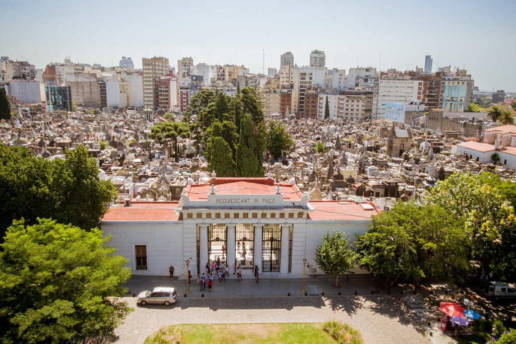
- RECOLETA CEMENTERY
Recoleta cemetery is considered one of the most beautiful cemeteries in the world and a must see site in Buenos Aires. This famous cemetery is the final resting site of some of Argentina’s most elite citizens, founding fathers, heroes and of course well off families showing off their wealth with increasingly more elaborate tombs. The mausoleums occupy roughly 14 acres divided by alleyways, tree lined streets and brick laid paths.
Many of the cemetery’s older, elaborate tombs were constructed with imported French or Italian materials. The architecture (yes, some of these mausoleums are that big) varies throughout this city of the dead from Art Deco to Baroque and are a photographers dream. For a more in depth experience Contact Us and book a local professional English speaking guide.
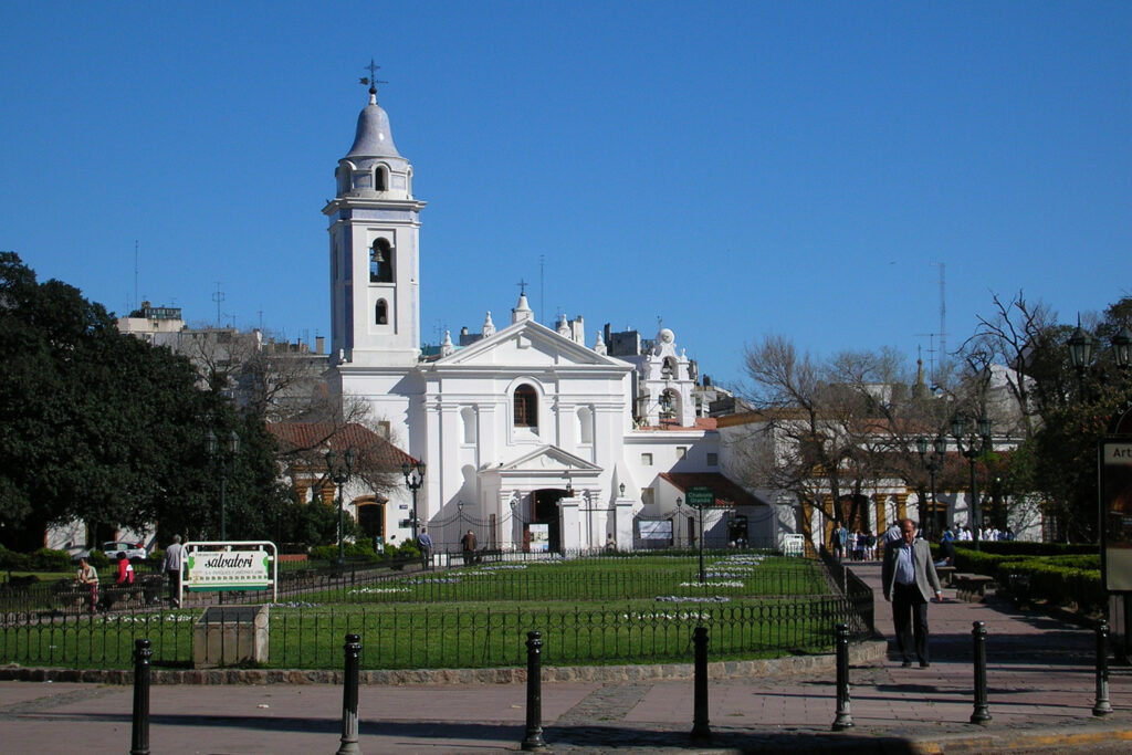
- DEL PILAR CHURCH
Attached to the cemetery is the brilliant-white church of Nuestra Señora del Pilar, which symbolizes the heart of the barrio. It is the oldest in our city preserved in its original baroque style. Because San Ignacio, which is older, only retains a tower and the façade from its construction.
- LA BIELA CAFE
A culinary passion that began in the mid-nineteenth century, and was renamed until finally reaching “La Biela.” Keeping its initial essence, it became the favorite meeting place for Buenos Aires citizens. One of the most historic and prestigious bars in the Autonomous City of Buenos Aires, which is presented as the must-see destination.
The emblematic La Biela coffee store is a place that used to be frequented by icons of Argentine literature, such as Jorge Luis Borges, Adolfo Bioy Casares and Ernesto Sábato, as well as old glories of the sport such as Juan Manuel Fangio and Jorge Newbery, among others.
- CENTRO CULTURAL RECOLETA
Recoleta is also home to the magnificent Museo Nacional de Bellas Artes, displaying work by Goya and Rembrandt and offering free entrance from Tuesday to Sunday, and the funky-looking Biblioteca Nacional ( National Library).
Opening hours
- Tuesday to Friday, 11 am to 8 pm; Saturday and Sunday, 10 am to 8 pm.
- Monday: closed.
- Free admission
- EVITA MONUMENT
It was designed by Argentinian sculptor Ricardo Gianetti and it was inaugurated at the foot of a cliff dubbed Plaza Evita on December 6, 1999. The figure of Mrs. Eva Duarte de Perón stands on a pedestal made of black ceramic in the shape of a Latin cross.
María Eva Duarte de Perón (1919–1952), usually referred to as Eva Perón or by the affectionate diminutive Evita, was the second wife of President Juan Perón (1895–1974) and served as the First Lady of Argentina from 1946 until her death. Over the years, she became a part of international pop culture, most famously as the subject of Tim Rice’s musical, Evita.
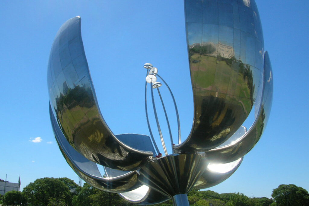
- FLORALIS GENERICA
Designed and paid by Argentine architect Eduardo Catalano, the Floralis Generica, a giant silver flower, has been a striking city landmark since it opened in 2002.
The enormous metal flower blooms anew each day in a pool of water next to the National Museum of Fine Arts, revealing four long stamens inside. Its six 13-meter-long petals open, which takes about 20 minutes, at eight in the morning and slowly close again at sunset, mimicking the actions of a real flower. When the petals are closed, the 18 ton flower is 75 feet tall and 52 feet wide, and when blossomed this amazing man-made flora is an incredible 105 feet wide.
105-foot wide giant metallic flower blooms anew every day in the heart of Buenos Aires.
- PLAZA INTENDENTE ALVEAR (known as Plaza Francia)
This pleasant green space is the perfect place to stop for a rest. It’s named after its central monument From France to Argentina, which was donated by the city’s French community to mark the centennial of Argentina’s May Revolution in 1910.
- PLAZA INTENDENTE FOTO DEL DE
This pleasant green space is the perfect place to stop for a rest. It’s named after its central monument From France to Argentina, which was donated by the city’s French community to mark the centennial of Argentina’s May Revolution in 1910.
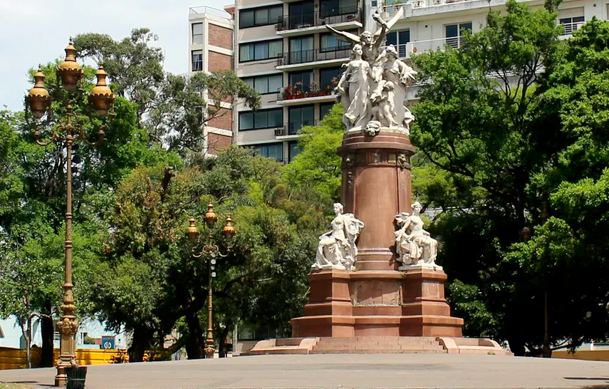
Monument offered as a gift by the French community in 1910, on the occasion of the Centenary celebrations. It is a work by the French sculptor Émile Edmond Peynot (1850 – 1932). The sculpture’s three central marble figures represent Science, Industry, Agriculture and the Arts
More than just a weekend street fair, the Feria of Recoleta is the heart of the district. The most popular of the Buenos Aires Saturday markets you will find every type of person and thing for sale at the recoleta weekend fair.
Open on the weekends and holidays and located at the corner of Pueyrredon Avenue and Libertador Avenue and expanding across Plaza Francia it is the best place to get souvenirs of the city and of Argentina. A must visit location while you are in Recoleta, make sure you schedule your visit for when the market is open. Street food, live music and performers such as acrobats can also be found here. It is family friendly, but you’ll also be savoring the Buenos Aires bohemian spirit which is rich in Recoleta.
Opening on Saturday and Sunday, as well as holidays, from 11am or just before noon until 6pm or dusk.
Crossing Avenida de Libertador – one of the city’s main avenues – you can kick back in the well-kept gardens of Parque Thays or Plaza Justo Jose de Urquiza, the latter of which houses a rotating sculpture display and stretches to the border of Palermo.
If you are interested in learning more about this fascinating neighborhood, Ideas offers the best walking tours of Buenos Aires since 2004. Contact us and we will plan an unforgettable walking tour in Recoleta.
Contact Us if you have any questions or if you want to start planning your trip for 2022.