

Scenic Drives:
The 15 best places to visit on Route 40
Ruta Nacional 40 is the name of a very scenic drive in western Argentina, stretching from Santa Cruz Province in the south to Jujuy Province in the north. Running parallel to the Andes mountains, Argentina’s Ruta 40 is one of the longest and most spectacular highways in the world. Ruta 40 now starts at the ocean at Cabo Vírgenes and winds north through eleven provinces, past twenty national parks and across 24 major rivers, before reaching the altiplano.
Choosing the best attractions and destinations along Route 40, Argentina is not an easy task because there are many sites, natural and cultural monuments, historical landmarks, incredible landscapes and cultural events along its winding route.
Here we list the “15 Best Attractions” of Route 40 that we consider unique and worth visiting. These attractions are listed from north to south.
# 1: Cusi Cusi
The “Valley of Mars”
Jujuy Province
A multi-colored valley with ocher, red, pink, white and gray tones, located on the Plateau de la Puna in the province of Jujuy.
It is also known as “Valle de la Luna 2” (since Valley number 1 is Ischigualasto in San Juan). The Cusi Cusi Valley is located at an altitude of 3,800 m – 12,460 ft on a gravel (gravel) stretch of Route 40 between Susques and La Quiaca.
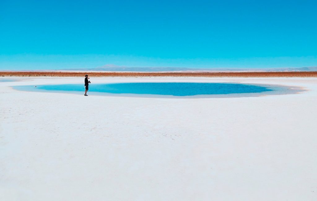
# 2: Salinas Grandes
Salinas in the Puna
Jujuy and Salta
The “Salinas Grandes” (which means “Salinas Grandes”) extend for 212 km2 in the highlands of the Puna at 3,450 meters high.
The vast surface of white salt contrasts with the deep blue sky. It is a temporary lake when it rains, and the salt is harvested using traditional methods. It is located on the border of the provinces of Jujuy and Salta, and the “old” Route 40 runs along its southern and eastern shore. National Route 52, paved, crosses it and connects Susques and Purmamarca.
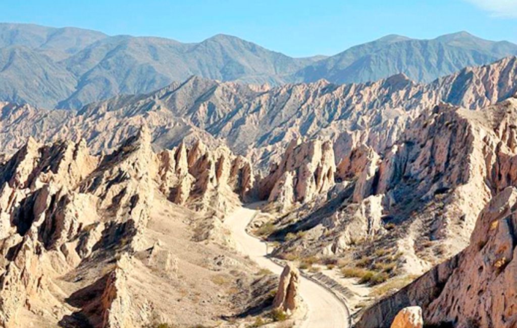
# 3: Abra del Acay
The highest point on Route 40
Jump
The Abra del Acay is the highest pass on a national highway in the world and the highest highway pass outside of Asia: it stands at 16,050 feet. (4,895 m) above sea level.
Located in the Cordillera del Nevado del Acay de los Andes, it is a difficult mountain road between the towns of San Antonio de los Cobres and Cachi.
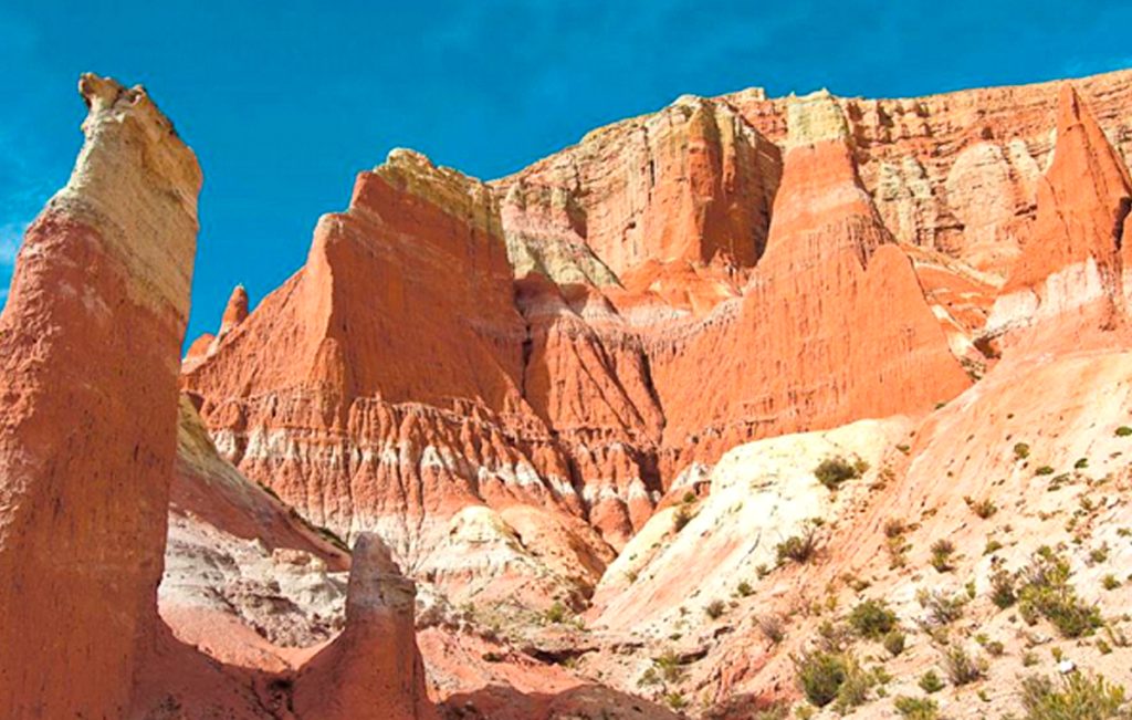
# 4: Quebrada de las Flechas
Incredible rock formations in the Calchaquí River Valley
Jump
A lunar landscape in the heart of the Calchaquí Valleys. Strange sloping layers of ash-colored rock protrude up to 150 feet above the surrounding terrain.
Its name means “Barranco de las Flechas”, where the “arrows” are the sharp angular slabs of rock.
They are part of the protected area, the Angastaco Natural Monument.
# 5: Shinkal de Quimivil
Prehispanic ruins
Catamarca
The Shinkal (or Shincal) is a National Historic Monument that preserves the Inca ruins.
It covers nearly 50 acres of what was once a provincial capital in the Inca Empire. More than 100 buildings, including a “pyramid”, are on the site.
It is located on the outskirts of the city of London (London), along Route 40.
# 6: Cuesta de Miranda
The Rioja
La Cuesta de Miranda, is a section of Route 40 that was famous for its dangerousness: a narrow one-lane road that winds through the Miranda River canyon. It crosses a gap between the 19,000-foot-high Famatina Mountains and the Cordillera de Sañogasta.
It is now a paved road and it is safe and easy to drive. It is located between the towns of Chilecito and Villa Unión in the province of La Rioja and its maximum height is 6,690 feet. (2,040 m) above sea level.
# 7: Talampaya and Ischigualasto
National and Provincial Parks and a UNESCO World Heritage Site
La Rioja and San Juan
Both parks are part of the UNESCO World Heritage Site, the Talampaya National Park is located in the province of La Rioja, and is next to the Ischigualasto Provincial Park in the province of San Juan.
They are known for their rock formations, dinosaur fossils, pre-Hispanic rock art, and their native animals and plants. You can get from Route 40 to Jáchal, Huaco or Villa Unión.
#8: Cerro Aconcagua
Mendoza
Cerro Aconcagua, often referred to as simply Aconcagua, is a mountain in Argentina near its border with Chile. Aconcagua is the highest peak in the Western Hemisphere. It is second in height after Mount Everest. The first known attempt to reach the mountain’s summit was made in 1883, but the attempt failed. In 1897, Swiss mountaineer Matthias Zurbriggen became the first known climber to successfully reach the summit. It is more than 6,706 meters (22,000 feet) high, Aconcagua is part of the Andes Mountains chain and it is one of the Seven Summits.
# 9: El Payén
La Payunia Provincial Reserve
Mendoza
El Payén or Payunia, is a volcanic region with large lava flows, basaltic rocks and volcanoes.
It averages 2.75 volcanoes per 10 square miles and disputes with the Siberian Peninsula of Kamchakta for the title of “most volcanoes in a given area” worldwide.
Its lava flows and lava fields are among the largest in South America.
# 10: Route of the Seven Lakes
Route 40 in the Patagonian forests and the lake region
Neuquén and Río Negro
Route 40 between the cities of Bariloche, Río Negro and San Martín de los Andes in Neuquén is known as the “Route of the Seven Lakes”.
The road is completely paved and crosses two National Parks, in the Andean forests and runs along the shores of more than seven lakes today. The highway is aligned in the Andes, with its forested slopes, a pristine area protected by the Nahuel Huapi and Lanín National Parks.
# 11: Bariloche
Bariloche is the gateway city to the Andean lakes district in Argentine Patagonia. This alpine-style town is known for its high quality Patagonian food, high quality chocolate and the beauty of its unspoiled nature. It is located very close to Cerro Catedral, the largest ski resort in South America. There are many reasons to visit Bariloche: the beauty of unspoiled nature, horse riding, fishing, trekking & hiking, navigation, mountain biking, rafting, kayaking, canopy, snow and ski, amongst other outdoor sports. n Bariloche there are many different accommodation options to suit all needs and budgets: luxury hotels, lodges, hostels, apartments, cabins, youth hostels and camping sites.
# 12: The Cave of the Painted Hands
One of the most important Paleolithic detachments in the world
Santa Cruz
Declared a UNESCO World Heritage Site, the caves of the hands offer a trip to the past to understand the life of the Indians of Patagonia.
# 13: Petrified Forest La Leona
The Petrified Forest closest to Tourism
Santa Cruz
Just 100 kilometers before reaching El Calafate is the most easily accessible Petrified Forest.
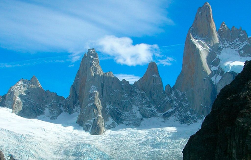
#14: Fitz Roy Mountain
El Chalten, Santa Cruz
The hike to Mount Fitz Roy is one of the most popular hikes in Los Glaciares National Park and the village of El Chaltén. It’s most often done as a long day trip, but if you prefer to take your time there are two campgrounds along the route.


No comment yet, add your voice below!