The Most Scenic Road trip: Driving Route 40

The Most Scenic Road trip: Driving Route 40

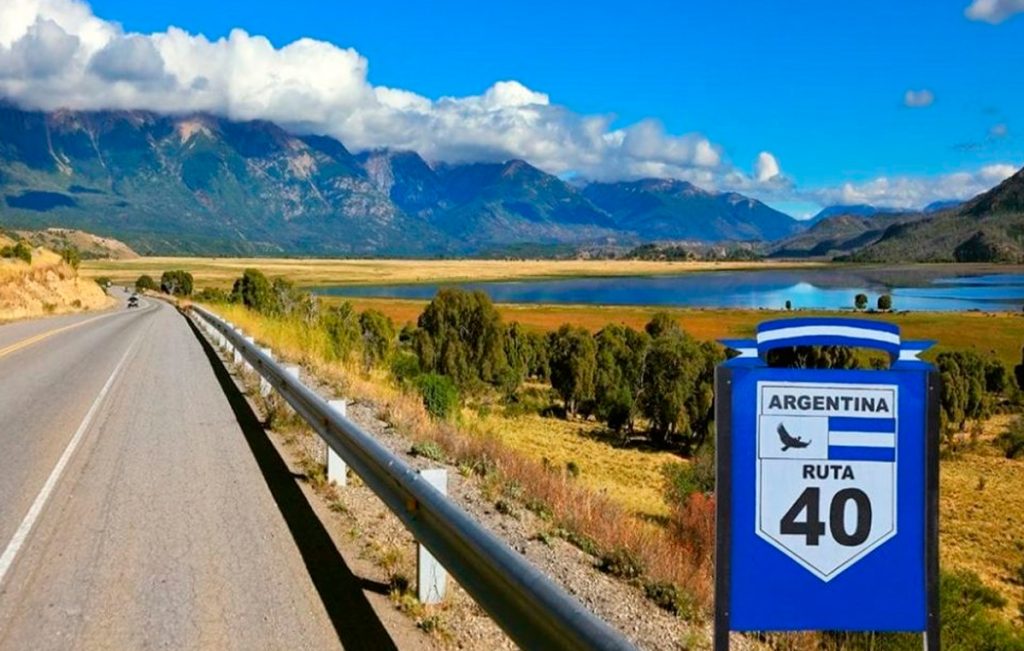
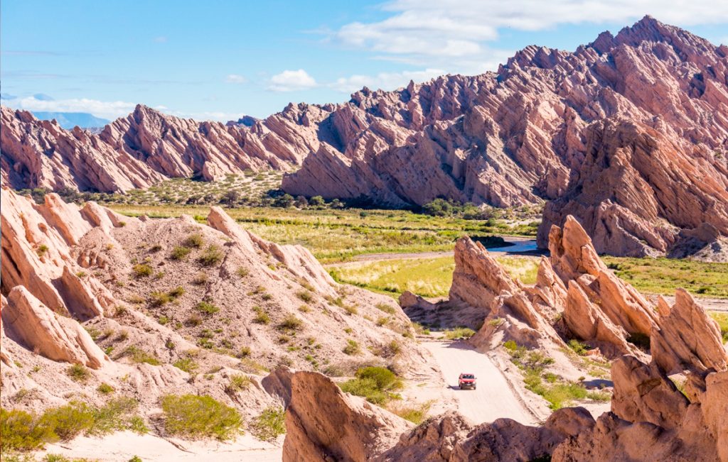
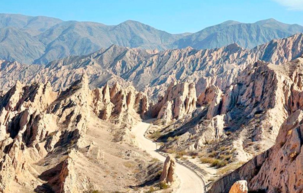
Argentina’s Route 40 is one of the longest and most impressive scenic drives in the world, taking you 3,000 miles alongside the Andes Mountains. With its highest point at more than 16,600 feet (5,061 m), it breaks the world record for the highest national road. The route goes from the southernmost tip of Argentina to the Bolivian border and so the terrain is hugely diverse, from winding mountain passes to expansive open spaces.

Equivalent to Route 66 the “Mother road” in the United States, route 40 is the ultimate Argentine road trip, made famous by its role in Che Guevara’s ‘The Motorcycle Diaries’. It crosses 18 important rivers, 20 National Parks and Natural Reserves and connecting 11 provinces: Santa Cruz, Chubut, Río Negro, Neuquén, Mendoza, San Juan, La Rioja, Catamarca, Tucumán, Salta and Jujuy. On this spectacular route, you’ll pass through everything from wetlands to breathtaking glaciers.

Unesco World Heritage Sites along Route 40

Along its entire length, Route 40 crosses incredible landscapes. Among its main attractions, there are several sites that are considered world heritage.

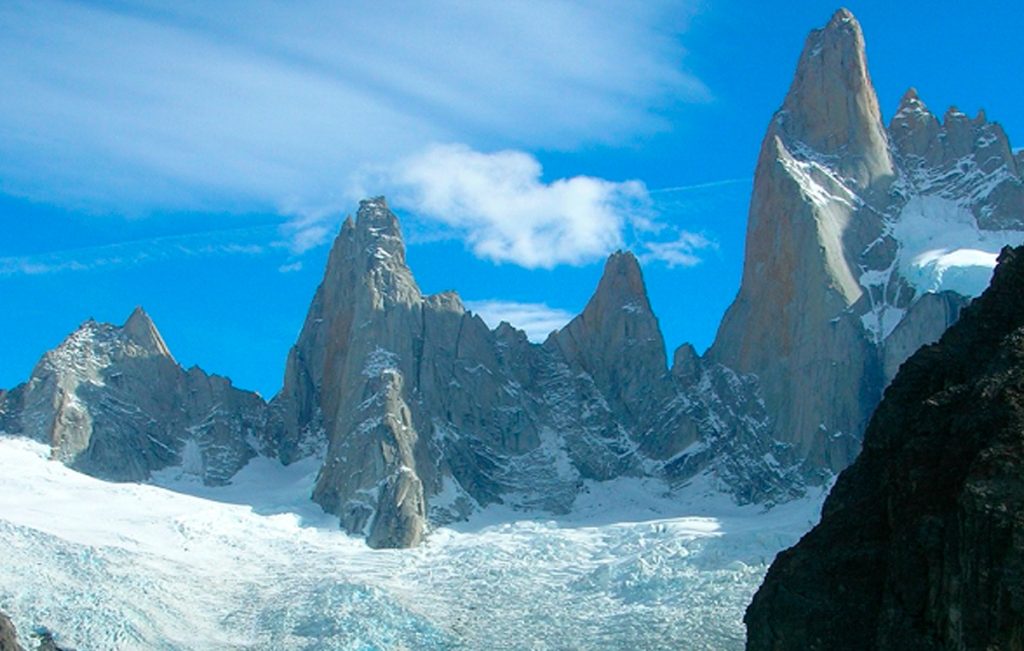
• Los Glaciares National Park: Its natural beauty made it appropriate the UNESCO title. The ice field comprises a vast region of the mountain range. The absolute “star” of all glaciers is the Perito Moreno Glacier, over the south branch of Lake Argentino. It has an imposing front wall of 5 km. and it is 60 meters tall. But there is an even bigger one: the Upsala Glacier,10 km. wide and 50 m. tall. At the north of the Park, another gem: Mount Fitz Roy, a true challenge for mountain climbers with its 3,375 meters.

Cave of the painted hands: It is an archaeological site in Santa Cruz and, due to its antiquity, continuity over time, beauty and conservation, it was declared a unique pictorial complex in the world. The archaeological and paleontological importance of the site lies in the fact that these paintings of hands, animals and geometric figures made on the rocks are considered the oldest expressions of the South American people. Even in the region, near the Perito Moreno National Park, there are vestiges that demonstrate the existence of life from about 14 thousand years B.C. Specialists distinguish three stylistic types. The oldest, dating back 9,500 years, shows negatives of hands, hunting scenes and fences with snares, rituals and herds of guanacos. The next one goes from 7,000 to 3,000 years ago and there we can see negative hands, groups of pregnant guanacos and some amphibians and ñandués, and feline figures. The last group, 2,500 years old, shows human figures, schematic hands, geometric figures, concentric circles, zigzag lines, all in vibrant red.

Los Alerces National Park: The larches that inhabit the forest are one of the longest-lived species on planet Earth. Its thousand-year-old forest earned it the distinction. The alerce trees are massive trees from the cypress family that resemble those of Sequoia National Park in California, United States. The largest known tree in the park is 187 feet (57 m) tall and 7.2 feet (2.2 m) in diameter. It is estimated to be 2,600 years old. The alerce trees are the second-longest living species of trees in the world. The most popular alerce forest is located on the northern end of Lake Menendez. Boat tours to this region allow visitors to experience this magnificent forest and the park's largest known tree. The national park is an excellent place to hike and explore the remarkable wilderness.

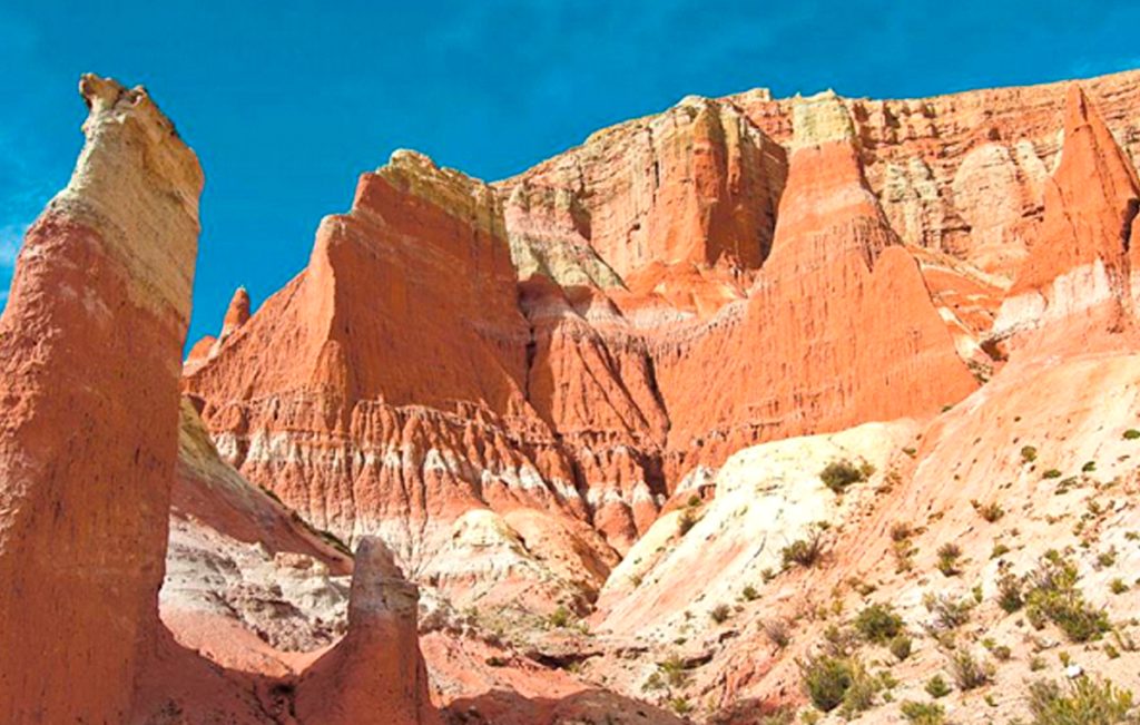
• Ischigualasto Provincial Park: Also known as the Moon Valley "Valley of the Moon", in San Juan; Talampaya National Park, in La Rioja. Both parks shelter archaeological and paleontological treasures. Ischigualasto covers 63 thousand hectares and only a very limited area is available for tourists; the rest, know it, is the subject of permanent study and research, the exclusive territory of the wise. The visit is only carried out with a guide, who is in charge of illustrating the most relevant aspects that the landscape shows: the amazing Bocce Court where countless spheres of stones are scattered; the figures of the Submarine (with two well-differentiated upper parts) and the Mushroom (with a single wider part); the little towers or watchtowers, on the crest of another mound; The worm; the Los Colorados wall and its ocher yellow plinth, whose colors shine more intensely at sunset; the grayish blue hills, and so many other lunar landscapes that the valley keeps.
Attached to the entrance to the Park is the headquarters of the Museum of Natural Sciences of San Juan. The function of the museum lies in showing the scientific importance of Ischigualasto, which are the most outstanding species that have been found and what the work of a paleontologist is like with the fossil remains found in the place. Biology and geology students are in charge of transmitting their experiences in this field in a didactic and entertaining way for any age. And the boys in particular have a blast; Full of enthusiasm, they ask questions that adults don't always dare to ask.

• In the museum you can see the replica of the Eoraptor lunensis, the great discovery of the Ischigualasto basin, considered the most primitive dinosaur in the world. Almost a meter tall, it has morphological characteristics that place it as the least evolved of the dinosaurs that lived together in the Triassic.

Humahuaca. The towns of the ravine crossed by the Grande River interweave their cultural roots in a perfect combination of landscape and archaeological heritage. Along 155 km, the narrow valley that fertilizes the Grande River keeps enclaves more or less known and some little visited such as Volcán, Tumbaya, Sapagua, Huacalera, Maimará, among others. 
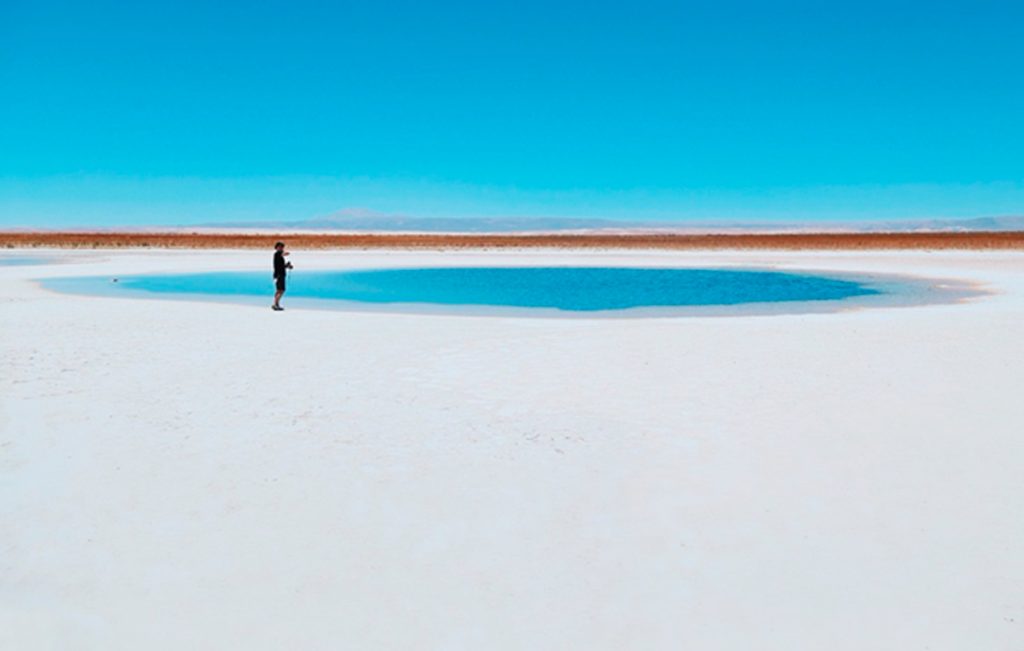
Geological wonders aside, Quebrada de Humahuaca holds the story of Argentina itself. The desert valley has preserved evidence of life dating back 10,000 years, from early hunter-gather tribes to pre-Hispanic communities, Incan culture, Spanish colonizers, all the way to the struggle for independence in the 20th century.

What is the best time of the year to drive Route 40?

Autumn and spring are ideal for traveling along Route 40 in any of its sections, due to the milder climate along its entire length. In Patagonia it is low season for tourism. Driving on the road does not require as much extreme care as if it were winter. And the colors explode in these times, showing all that is wonderful in nature.

In the north there is a coexistence of the mountain climate with the subtropical climate and the rainy season is summer. Autumn leaves behind the high temperatures and the climate becomes drier and more temperate.

Winter is also a good decision to explore the landscapes of the northwest, since the cold is not extreme and when the sun comes out it allows you to enjoy a little warmth on your skin.

Mendoza is considered the land of the sun and good wine. This idea can be extended to all of Cuyo. The warmest temperatures are in autumn and spring. Summer tends to be rainier. Winter is not so harsh and allows you to enjoy the outdoors.

Along the route to the south, the summer season tends to be a good option, especially in the southernmost Patagonia, when the routes are freed from ice and snow. Summer and the first days of autumn are optimal choices. The days are longer, ideal for enjoying the beaches of the southern lakes.

How to plan this trip to Route 40

You should plan at least 10 days to two weeks for your Route 40 trip, even more if you really want to enjoy the route. If you are in a hurry, the road can be covered in 8-10 days.

Keep in mind that to travel certain places such as climbing the Abra del Acay in the north as well as to travel some ranch roads in the south you may need an all-terrain vehicle.
You will have an absolute blast and driving the Ruta 40 will remain as one of our stand-out experiences of your life. But you do need to be prepared.

Traveling so many miles and covering such an important extension has its challenges. It's not the kind of trip where you can just hop in the car and set off. Large extensions of Patagonia are completely deserted and road sections are unpaved. On long stretches you will not find gas stations, places to buy food, nor will you find help to change a tire.

Scenic Drives: The 15 best places to visit on Route 40

Scenic Drives:

The 15 best places to visit on Route 40

Ruta Nacional 40 is the name of a very scenic drive in western Argentina, stretching from Santa Cruz Province in the south to Jujuy Province in the north. Running parallel to the Andes mountains, Argentina’s Ruta 40 is one of the longest and most spectacular highways in the world. Ruta 40 now starts at the ocean at Cabo Vírgenes and winds north through eleven provinces, past twenty national parks and across 24 major rivers, before reaching the altiplano.

Choosing the best attractions and destinations along Route 40, Argentina is not an easy task because there are many sites, natural and cultural monuments, historical landmarks, incredible landscapes and cultural events along its winding route.

Here we list the “15 Best Attractions” of Route 40 that we consider unique and worth visiting. These attractions are listed from north to south.

# 1: Cusi Cusi

The “Valley of Mars”
Jujuy Province
A multi-colored valley with ocher, red, pink, white and gray tones, located on the Plateau de la Puna in the province of Jujuy. It is also known as “Valle de la Luna 2” (since Valley number 1 is Ischigualasto in San Juan). The Cusi Cusi Valley is located at an altitude of 3,800 m – 12,460 ft on a gravel (gravel) stretch of Route 40 between Susques and La Quiaca.

# 2: Salinas Grandes

Salinas in the Puna
Jujuy and Salta
The “Salinas Grandes” (which means “Salinas Grandes”) extend for 212 km2 in the highlands of the Puna at 3,450 meters high.
The vast surface of white salt contrasts with the deep blue sky. It is a temporary lake when it rains, and the salt is harvested using traditional methods. It is located on the border of the provinces of Jujuy and Salta, and the “old” Route 40 runs along its southern and eastern shore. National Route 52, paved, crosses it and connects Susques and Purmamarca.

# 3: Abra del Acay

The highest point on Route 40
Jump
The Abra del Acay is the highest pass on a national highway in the world and the highest highway pass outside of Asia: it stands at 16,050 feet. (4,895 m) above sea level.
Located in the Cordillera del Nevado del Acay de los Andes, it is a difficult mountain road between the towns of San Antonio de los Cobres and Cachi.

# 4: Quebrada de las Flechas

Incredible rock formations in the Calchaquí River Valley
Jump
A lunar landscape in the heart of the Calchaquí Valleys. Strange sloping layers of ash-colored rock protrude up to 150 feet above the surrounding terrain.
Its name means “Barranco de las Flechas”, where the “arrows” are the sharp angular slabs of rock.
They are part of the protected area, the Angastaco Natural Monument.

# 5: Shinkal de Quimivil

Prehispanic ruins
Catamarca
The Shinkal (or Shincal) is a National Historic Monument that preserves the Inca ruins.
It covers nearly 50 acres of what was once a provincial capital in the Inca Empire. More than 100 buildings, including a “pyramid”, are on the site.
It is located on the outskirts of the city of London (London), along Route 40.

# 6: Cuesta de Miranda

The Rioja
La Cuesta de Miranda, is a section of Route 40 that was famous for its dangerousness: a narrow one-lane road that winds through the Miranda River canyon. It crosses a gap between the 19,000-foot-high Famatina Mountains and the Cordillera de Sañogasta.
It is now a paved road and it is safe and easy to drive. It is located between the towns of Chilecito and Villa Unión in the province of La Rioja and its maximum height is 6,690 feet. (2,040 m) above sea level.

# 7: Talampaya and Ischigualasto

National and Provincial Parks and a UNESCO World Heritage Site
La Rioja and San Juan
Both parks are part of the UNESCO World Heritage Site, the Talampaya National Park is located in the province of La Rioja, and is next to the Ischigualasto Provincial Park in the province of San Juan.
They are known for their rock formations, dinosaur fossils, pre-Hispanic rock art, and their native animals and plants. You can get from Route 40 to Jáchal, Huaco or Villa Unión.

#8: Cerro Aconcagua

Mendoza
Cerro Aconcagua, often referred to as simply Aconcagua, is a mountain in Argentina near its border with Chile. Aconcagua is the highest peak in the Western Hemisphere. It is second in height after Mount Everest. The first known attempt to reach the mountain’s summit was made in 1883, but the attempt failed. In 1897, Swiss mountaineer Matthias Zurbriggen became the first known climber to successfully reach the summit. It is more than 6,706 meters (22,000 feet) high, Aconcagua is part of the Andes Mountains chain and it is one of the Seven Summits.

# 9: El Payén

La Payunia Provincial Reserve
Mendoza
El Payén or Payunia, is a volcanic region with large lava flows, basaltic rocks and volcanoes.
It averages 2.75 volcanoes per 10 square miles and disputes with the Siberian Peninsula of Kamchakta for the title of “most volcanoes in a given area” worldwide.
Its lava flows and lava fields are among the largest in South America.

# 10: Route of the Seven Lakes

Route 40 in the Patagonian forests and the lake region
Neuquén and Río Negro
Route 40 between the cities of Bariloche, Río Negro and San Martín de los Andes in Neuquén is known as the “Route of the Seven Lakes”.

The road is completely paved and crosses two National Parks, in the Andean forests and runs along the shores of more than seven lakes today. The highway is aligned in the Andes, with its forested slopes, a pristine area protected by the Nahuel Huapi and Lanín National Parks.

# 11: Bariloche

Bariloche is the gateway city to the Andean lakes district in Argentine Patagonia. This alpine-style town is known for its high quality Patagonian food, high quality chocolate and the beauty of its unspoiled nature. It is located very close to Cerro Catedral, the largest ski resort in South America. There are many reasons to visit Bariloche: the beauty of unspoiled nature, horse riding, fishing, trekking & hiking, navigation, mountain biking, rafting, kayaking, canopy, snow and ski, amongst other outdoor sports. n Bariloche there are many different accommodation options to suit all needs and budgets: luxury hotels, lodges, hostels, apartments, cabins, youth hostels and camping sites.

# 12: The Cave of the Painted Hands

One of the most important Paleolithic detachments in the world
Santa Cruz
Declared a UNESCO World Heritage Site, the caves of the hands offer a trip to the past to understand the life of the Indians of Patagonia.

# 13: Petrified Forest La Leona

The Petrified Forest closest to Tourism
Santa Cruz
Just 100 kilometers before reaching El Calafate is the most easily accessible Petrified Forest.

#14: Fitz Roy Mountain

El Chalten, Santa Cruz
The hike to Mount Fitz Roy is one of the most popular hikes in Los Glaciares National Park and the village of El Chaltén. It’s most often done as a long day trip, but if you prefer to take your time there are two campgrounds along the route.

# 15: Perito Moreno Glacier

The most famous glacier in Patagonia
Santa Cruz
The Perito Moreno glacier is unique in that it does not recede, but advances, damming Lake Argentino, periodically bursting in a spectacular rupture of the ice dam when the pressure of the lake’s water breaks it.
It is located in Los Glaciares National Park, a UNESCO World Heritage Site, near the city of El Calafate.

SMART PLANNING
The extensive route of Route 40 requires a lot of research and planning time. We highly recommend working with a local expert to travel safely and with peace of mind. Our travel designers are always up to date with the latest news and guidelines. Throughout your trip you’ll have in-country support ready to jump in and take care of any eventuality. You can take it easy, knowing you’ll be fully supported even when the unexpected happens.